 OpenLayers makes it easy to put a dynamic map in any web page. It can display map tiles, vector data and markers loaded from any source. OpenLayers has been developed to further the use of geographic information of all kinds. It is completely free, Open Source JavaScript, released under the 2-clause BSD License (also known as the FreeBSD). Tiled Layers: Pull tiles from OSM, Bing, MapBox, Stadia Maps, and any other XYZ source you can find. OGC mapping services and untiled layers also supported.
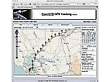 OpenGTS provides a web-based GPS tracking collection system. It joins positional data from a fleet of devices or vehicles. It supports OpenLayers and other map providers, a detail and summary report, and various types of GPS tracking devices.
Mapollage is a photo kml generator for Google Earth, a photo kml maker. Create kml folders by directory name, date pattern and regex Name placemarks by filename and date pattern Use a photo or a pin as a marker Dynamic description generator Customizable photo reference Draw path between placemarks
GeoServer is a Java-based server that allows users to view and edit geospatial data. Using open standards set forth by the Open Geospatial Consortium (OGC), GeoServer allows for great flexibility in map creation and data sharing. Open and Share Your Spatial Data GeoServer allows you to display your spatial information to the world. Implementing the Web Map Service (WMS) standard, GeoServer can create maps in a variety of output formats. OpenLayers, a free mapping library, is integrated into Ge
OpenGTS provides a web-based GPS tracking collection system. It joins positional data from a fleet of devices or vehicles. It supports OpenLayers and other map providers, a detail and summary report, and various types of GPS tracking devices.
Mapollage is a photo kml generator for Google Earth, a photo kml maker. Create kml folders by directory name, date pattern and regex Name placemarks by filename and date pattern Use a photo or a pin as a marker Dynamic description generator Customizable photo reference Draw path between placemarks
GeoServer is a Java-based server that allows users to view and edit geospatial data. Using open standards set forth by the Open Geospatial Consortium (OGC), GeoServer allows for great flexibility in map creation and data sharing. Open and Share Your Spatial Data GeoServer allows you to display your spatial information to the world. Implementing the Web Map Service (WMS) standard, GeoServer can create maps in a variety of output formats. OpenLayers, a free mapping library, is integrated into Ge
 QGIS (Quantum GIS) is a geographic information systems (GIS) application for viewing, editing, and analysing data. It allows layered map editing, composed of raster and vector (polygon) data, and allows georeferencing them. It's commonly used by OpenStreetMap and suitable for beginners, also available cross-platform.
OpenSCD, the SCL editor for your browser, allows you to engineer and validate IEC 61850 substations.
QGIS (Quantum GIS) is a geographic information systems (GIS) application for viewing, editing, and analysing data. It allows layered map editing, composed of raster and vector (polygon) data, and allows georeferencing them. It's commonly used by OpenStreetMap and suitable for beginners, also available cross-platform.
OpenSCD, the SCL editor for your browser, allows you to engineer and validate IEC 61850 substations.
 Fimex is a the File Interpolation, Manipulation, and EXtraction library for gridded geospatial data. It converts between different, extensible data formats (currently netcdf, NcML, grib1/2, metgm, wdb, and felt). It enables you to change the projection and interpolation of scalar and vector grids. It makes it possible to subset the gridded data and to extract only parts of the files. The library is written in C/C++ and as extensions to Fortran and R. For simple usage, Fimex also comes with the c
|