 OpenLayers makes it easy to put a dynamic map in any web page. It can display map tiles, vector data and markers loaded from any source. OpenLayers has been developed to further the use of geographic information of all kinds. It is completely free, Open Source JavaScript, released under the 2-clause BSD License (also known as the FreeBSD). Tiled Layers: Pull tiles from OSM, Bing, MapBox, Stadia Maps, and any other XYZ source you can find. OGC mapping services and untiled layers also supported.
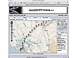 OpenGTS provides a web-based GPS tracking collection system. It joins positional data from a fleet of devices or vehicles. It supports OpenLayers and other map providers, a detail and summary report, and various types of GPS tracking devices.
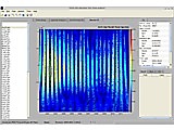 Gitsa processes and analyzes time series in earth science from GPS data. It calculates basic statistics or quality parameters, such as mean and variance. It ca import and visualize different standard time series formats, isolate outliers, export the aquired data sets, or generate graphical representations.
|