Recent Releases
1.6.030 Apr 2023 12:50
major feature:
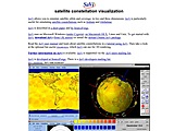
The SaVi 1.6.0 release (30 April 2023) integrates with v1.2 of the satellite plot
scripts for better presentation of SaVi coverage maps, adds a reworked hierarchical
menu structure with submenus, adds simulations of Audacy, Karousel, Project Kuiper,
Laser Light/HALO, RADARSAT, Starlink, Telesat, Theia and Viasat LEO constellations,
adds simulations of Singh's geosynchronous 4-satellite constellations as described
in Nature Communications, increases maximum number of coverage colors to 29 for
megaconstellations with a direct popup menu, adds menu options for coverage map size,
adds -small-map and -all-maps options, associates fisheye, sunlight and geostationary
satellite behaviour with simulation constants, and suppports wider downloading of
TLEs using lynx.
1.5.102 Jul 2017 12:04
minor feature:
The SaVi 1.5.1 release (2 July 2017) adds a -max-transmit-altitude flag, improves Cygwin Tcl/Tk 8.6 compatibility, and includes minor bugfixes.
1.5.0b12 Jun 2017 11:56
minor feature:
The SaVi 1.5.0b release (June 2017) allows coverage maps to be saved directly as GIF image files, enables saving of animated coverage maps as gifanims by using gifsicle, adds ability to load TLE elsets directly from web, works to improve building on SGI Irix, handles Tcl's interp- result being considered deprecated in Tcl 8.5 and strongly discouraged in 8.6, fixes dynamic coverage compilation error seen in recent clang, fixes path-setting problems in launch script, includes instructions for building under Windows 10 Anniversary Edition, removes legacy numesh.oogl and has texturemapping always on.
The 1.5.0a release is a minor revision over 1.5.0 (September 2016), fixing two bugs: in detecting gifsicle, and in parsing unnamed elsets.
The 1.5.0b release is a minor revision over 1.5.0a (December 2016), improving accuracy of generated constellations through correct rounding.
1.5.0a11 Dec 2016 12:27
minor feature:
The SaVi 1.5.0a release (December 2016) allows coverage maps to be saved directly as GIF image files, enables saving of animated coverage maps as gifanims by using gifsicle, adds ability to load TLE elsets directly from web, works to improve building on SGI Irix, handles Tcl's interp- result being considered deprecated in Tcl 8.5 and strongly discouraged in 8.6, fixes dynamic coverage compilation error seen in recent clang, fixes path-setting problems in launch script, includes instructions for building under Windows 10 Anniversary Edition, removes legacy numesh.oogl and has texturemapping always on.
The 1.5.0a release is a minor revision over 1.5.0 (September 2016), fixing two bugs: in detecting gifsicle, and in parsing unnamed elsets.
1.5.004 Sep 2016 13:42
minor feature:
The SaVi 1.5.0 release (September 2016) allows coverage maps to be saved directly as GIF image files, enables saving of animated coverage maps as gifanims by using gifsicle, adds ability to load TLE elsets directly from web, works to improve building on SGI Irix, handles Tcl's interp- result being considered deprecated in Tcl 8.5 and strongly discouraged in 8.6, fixes dynamic coverage compilation error seen in recent clang, fixes path-setting problems in launch script, includes instructions for building under Windows 10 Anniversary Edition, removes legacy numesh.oogl and has texturemapping always on.
1.4.930 Jan 2016 05:20
minor feature:
The SaVi 1.4.9 release (30 January 2016) updates Geomview's footprints and cones dynamically when the coverage slider is used, enables coverage 'Show map' checkbox to control Geomview behaviour, adds speculative LeoSat and OneWeb star constellation simulations, removes now-legacy texturemap disk scratchfile needed by Geomview 1.8.1 to remove tmpnam() call, which was a showstopper for e.g. the Ubuntu linker, and improves finding binary executable on launch.
1.4.815 Jan 2015 12:56
minor feature:
The SaVi 1.4.8 release (15 January 2015) has some bugfixes
for the new projection added in 1.4.7, and extends Tcl/Tk
8.6 support.
The SaVi 1.4.7 release (5 January 2015) adds a duochrome option showing coverage shading over land and sea, models the equator and equatorial exclusion zones in the fisheye window, by showing parallels, used that to correct the Skybridge 64-satellite script, adds a -min-transmit-altitude flag and min_transmit_altitude bound variable to set a height at which elliptical constellations turn off signal away from apogee, and makes compilation easier on recent Mac OS X (10.9 and later).
1.4.704 Jan 2015 19:45
minor feature:
The SaVi 1.4.7 release (5 January 2015) adds a duochrome option showing coverage shading over land and sea, models the equator and equatorial exclusion zones in the fisheye window, by showing parallels, used that to correct the Skybridge 64-satellite script, adds a -min-transmit-altitude flag and min_transmit_altitude bound variable to set a height at which elliptical constellations turn off signal away from apogee, and makes compilation easier on recent Mac OS X (10.9 and later).